3: "Még egy hét csak." (Only one more week.)
Submitted by William Parkinson on Thu, 04/14/2011 - 00:00
© W.A. Parkinson
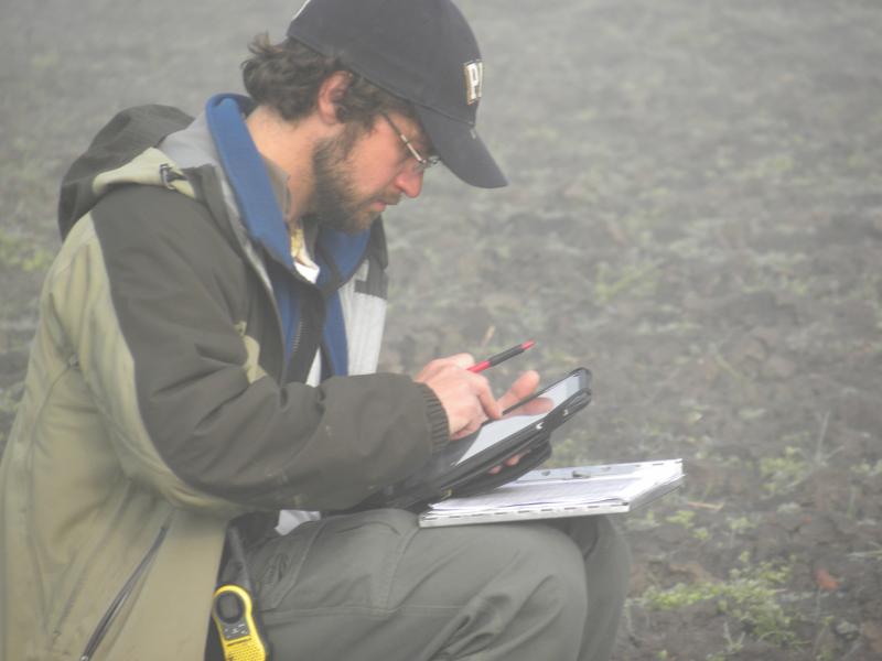
Entering Data
This is it. The last week of the season. We still have a lot to do, and the final week is always a massive rush to get everything done. In addition to finishing the excavation and survey, we need to complete the topography of the micro-region. But we also need to make sure that we’ve documented everything correctly with forms, photographs, and drawings. Then we need to back up all of our data. Since most of the information we record is now digital, we leave with multiple copies of the same datasets stored in different places—in Hungary, Greece, and the U.S., just to be safe.
Even in the last decade since we've been working in Vésztő, technology has improved considerably, which makes this part of the project much easier. During the first year of excavations at Vésztő-Bikeri in 2000, for example, we entered all our data onto paper forms, which we then entered into a database on a laptop. Now we use an iPad in the field and enter the data directly (see above photo.) This saves us hours of work each day.
We also take digital photos, rather than old-school film photos or slides. We’ve done this for years, but in the past, it was difficult to manage vast quantities of large images because neither the hard drives nor the storage media (floppy discs!) could handle the massive amount of data we generated. Just before I left Chicago, I bought a one-terabyte hard drive for a few hundred dollars, which easily will handle all the data for the season. This lets us be more efficient and focus on the work at hand.
And we really have been efficient this year! The geophysical team left last Thursday for their lab in Crete, where they’ll begin processing the huge amount of data they collected. We were very sad to see them go (see Photo #2 below.) They’re not only excellent collaborators, but also our dear friends. Two of our current grants (National Science Foundation—International Research Experience for Students; Wenner-Gren International Collaborative Research Grant) provide funding explicitly for training students, so several of the American and Hungarian students who are working with us in the field will go to the Foundation for Research and Technology, Hellas in Rethymnon, Crete, in a few weeks to learn how to process the data they collected while they were here. The lucky ducks!
We’re all very pleased with how much work the geophysical team accomplished while they were here. Apostolos Sarris and Nikos Papadopoulos concentrated primarily on continuing the magnetic prospection surveys they began last year, while Maria Christina Salvi conducted ground penetrating radar (GPR) surveys on several targets. I also spent several days ground-truthing targets that Maria Christina had identified from multi-spectral satellite images. As opposed to satellite photos, which record electromagnetic radiation only in the visible spectrum, multi-spectral images permit us to explore bandwidths beyond the visible spectrum.
Just before the season began, we learned that we’ve been awarded a grant from EUFAR (European Facility for Airborne Research) that will permit us to link the multi-spectral satellite imagery with hyper-spectral images taken from planes. Whereas the multi-spectral images contain a handful of different bands within the electromagnetic spectrum, the hyper-spectral images will contain hundreds of different bands. Athos Agapiou, one of our colleagues from Cyprus, has developed a technique that uses a handheld spectrometer for identifying archaeological features on the ground. He worked with us during the last week to test the method here, and it seems to have a lot of promise.
I cannot emphasize how exciting it is to have so many specialists on the project who are all doing cutting-edge research in their own disciplines. Apostolos, Nikos, and Athos, for example, all hold doctorates in physics. The project geomorphologist, Balázs Nagy, holds a doctorate in soil science, and Eniko Magyári, the palynologist and paleo-environmentalist, has her Ph.D. in earth science. It's very satisfying to have so many research scholars focus their efforts on, and bring their own contributions to, exploring common questions.
The magnetic surveys have continued to flesh out the picture of how the site was organized. We’ve identified more longhouses and other features throughout the micro-region that confirm and give nuance to how we thought the site was organized at the end of the last season. It appears that the longhouse clusters are not all isolated, for example. These patterns also are being confirmed by the surface collections, which exhibit discrete falloffs of archaeological materials in some areas, and more constant distributions in other areas.
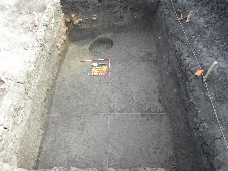
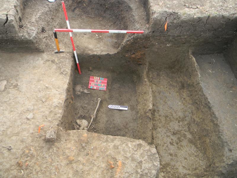
The excavations also have produced interesting results. E1B1—the test excavation unit over one of the isolated longhouses in the East Field—has produced good evidence of a structure, including a massive amount of daub and at least one posthole (see Photo #2 below.) Other than that, there’s very little additional material—very few pieces of pottery or animal bones. By contrast, S1B1—the excavation unit over one of the smaller structures in the South Field—has produced several superimposed features (see Photo #3 below.) In just one small 2x3-meter unit, we have discovered three trenches, a good Neolithic living surface, and two Neolithic burials. And we’re still digging!
These two small test excavation units were designed specifically to get dateable material from “sealed” excavation contexts that we can use to verify the magnetic anomalies and provide some time-depth to the picture we’ve built from the surface materials. Interestingly, the units demonstrate the same kind of patterns we witnessed in both the surface patterns and the magnetic surveys. Whereas the South Field seems to have been used very intensively, as indicated by the multiple activities we can discern even with a single 2x3-meter excavation unit, the dearth of finds in the East Field speaks to a much less intensive occupation.
Fortunately, both areas have produced ceramics and other materials that are consistent with the later Neolithic in the region, so we’re certain that the features date to the right time period. But it will require multiple absolute dates (such as radiocarbon dates) to determine the relative contemporaneity and duration of use of the different parts of the settlement.
As the project grinds on, everything begins to suffer from wear and tear. One of the 4x4s has been in for a new starter and some other repairs. Another overheated and may need more extensive work. The data collector for the GPS (who Dani Riebe named “Carl”) refused to work yesterday afternoon, and three students have had to stay in over the last week due to illness. But such things are to be expected with such a large field crew and with so many teams doing different things over such a large area.
All in all, we really couldn’t expect the project to go more smoothly, or to generate better results. I will write again after we have gotten everything closed up for the season to let you know how this last week goes.
More soon,
Bill

© W.A. Parkinson
The 2011 Team
© W.A. Parkinson
Block 1 East Field Overview
© W.A. Parkinson
S1B1 Overview
Recent Blog Posts
4. Winding Down
Thursday, April 11, 2013
These last couple weeks haven't been easy. We've made progress, but we've continued to be hammered...
3. Ez fáj! (This hurts!)
Thursday, March 28, 2013
We finally managed to get into the field last Thursday after the snows, rain, sleet, and hail. As...
2. Na! Haladjunk már! (Come on! Let's go already!)
Wednesday, March 20, 2013
Well, that was an interesting week! As I reported in my last dispatch, we were able to work from...