4. Analyzing Artifacts back at Home
Submitted by William Parkinson on Mon, 10/18/2010 - 10:23
© W.A. Parkinson
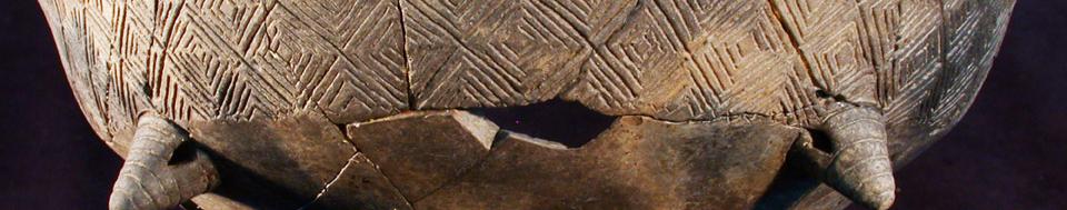
Storage Vessel Fragments
Thank you all for joining us and following along during our exciting field season in Hungary earlier this year! As promised, I wanted to send you a quick dispatch to fill you in on what’s been happening here at home after we returned from the field—and what our plans are for our upcoming spring expedition.
To help refresh everyone’s memory, this past spring, I and my colleagues on the Körös Regional Archaeological Project launched the initial survey expedition of the Szeghalom-Kovácshalom tell in the Great Hungarian Plain. Our goal is to explore and understand early village social dynamics and the growth of these prehistoric tells (raised, fortified settlements).
Most people seem to be surprised that we didn’t just delve into the tell, shovel first. But actually, the initial season at any archaeological site often involves lots of surface explorations and little, if any, excavation. Why? Because excavating is both time consuming and expensive, as well as destructive. A thorough understanding of the site and lots of planning must go into figuring out just exactly where to “dig in” effectively.
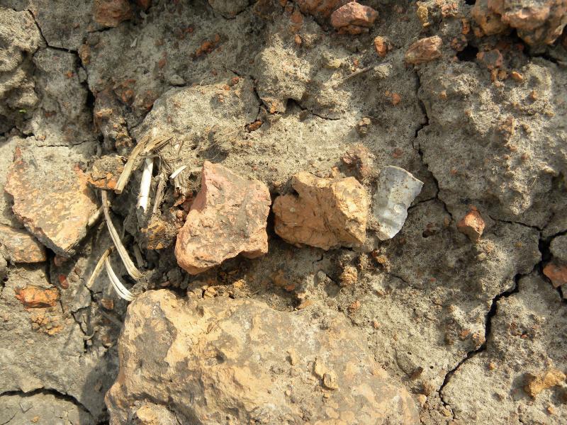
For example, in my past dispatches I mentioned that we spent this first year at the Szeghalom-Kovácshalom tell intensively surveying the site by: collecting artifacts lying on the surface of the ground (see above photo); scanning with magnetometers to locate structures hidden beneath the soil; using GPS to map the topography; and taking soil-core samples. All of these activities provided us with clues as to the site’s size, structure, ecology, etc., which are currently helping us better strategize about where to excavate in the upcoming seasons.
Essentially, we use the information gained from these non-invasive techniques to formulate several possible theories about the site and its role in the lives of prehistoric peoples. Then we excavate only in key places that will provide more details to flesh out our theories and answer remaining questions. The end result? We build a big picture of life at a site, while minimizing damage to both the landscape and the tell. Plus, by keeping much of the tell intact, we leave behind evidence for later study as archaeological techniques and technologies improve in the future.
So, having said that, I promised you more details and photos about what we’ve done with the info we collected after we returned home this past spring. First, you may recall that at the end of our survey season, we’d come to realize that Szeghalom-Kovácshalom wasn’t what we’d expected—a more-or-less isolated tell. Instead, our survey revealed that the site was not only surrounded by individual longhouses but also neighbored by a much larger settlement. And in addition to its walls and ditches, the tell was also once amply protected by streams that encircled the site, providing natural defense.
Having a new perspective on the site’s scope and scale, we’ve now begun analyzing the data and mapping our findings in a variety of ways to help us formulate our theories and determine where to dig this coming spring. To review how we started, while in the field, we tracked the types of materials we found, such as ceramics, burned bits of walls (daub), lithics (pieces of worked stone) etc., which told us something about how people used a particular area. (Feel free to browse through more images of our artifact finds in our Season 2010 Photo Gallery, which I’ve recently added.)
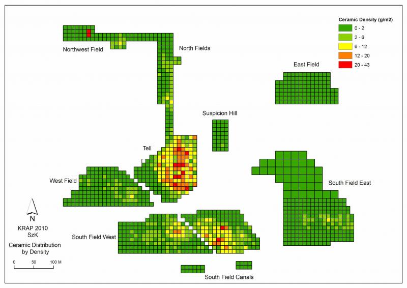
Then, both in the field and back at home, we created charts and maps noting the concentrations of each type of find, according to our 10x10-m grid system (see Photo #1 below.) Next, we overlaid these maps onto 3-D renderings of the topography (see Photo #2 below)—which we’d created using our GPS systems—to see the relationship between terrain and site use.
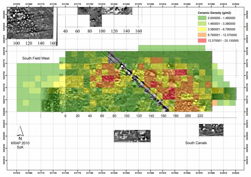
We also combined our magnetometry images with maps of our finds to confirm the locations and type/intensity of use for features like the longhouses and the larger settlement (See Photo #3 below.) Plus, we mapped out the soil chemistry samples to better determine site organization and length of occupation (see Photo #4 below.)
Altogether, these various visualizations help us develop theories and models of the natural and manmade processes at work that formed and shaped the site. We can now envision two possible scenarios for the site’s development.
- Scenario #1 might be that the 21 isolated longhouses encircling the tell predate the establishment of the tell itself, as well as the intensively occupied nearby settlement. In other words, perhaps longhouses were “stage one” in the settlement of a three-stage site evolution from longhouses, to settlement, to tell.
- Alternately, Scenario #2 might be that the longhouses date to the same time period as both the tell and the settlement, but represent special-purpose features (ritual spaces, etc.) at the edges of the settlement complex.
In preparation for our upcoming Spring 2011 trip, we’re now in the process of targeting which areas to excavate next year that will help us test our above hypotheses by answering questions like:
- Were the longhouses, the tell, and the settlement established consecutively? If so, which was founded first and which was occupied longest?
- Or, were all three founded and used at the same time, and if so, how did they interact?
- Did the longhouses play a ritual role for those who lived in the tell and settlement?
- Did climate or other environmental changes influence the growth of the site from one type of habitation to another?
Stay tuned next April when we head back out into the field to begin excavations. Our goal is to not only reconstruct life at Szeghalom-Kovácshalom, but also to build a better and more cross-cultural understanding of why and how prehistoric people began congregating together and establishing large settlements.
Hope you’ll join us this spring!
Bill
© W.A. Parkinson
Artifact Density Map

© W.A. Parkinson
3D Reconstruction
© W.A. Parkinson
Magnetometry & Ceramic Density Maps

© W.A. Parkinson
Phosphate Concentrations
Recent Blog Posts
4. Winding Down
Thursday, April 11, 2013
These last couple weeks haven't been easy. We've made progress, but we've continued to be hammered...
3. Ez fáj! (This hurts!)
Thursday, March 28, 2013
We finally managed to get into the field last Thursday after the snows, rain, sleet, and hail. As...
2. Na! Haladjunk már! (Come on! Let's go already!)
Wednesday, March 20, 2013
Well, that was an interesting week! As I reported in my last dispatch, we were able to work from...