11: Touching Nueve Puntas’ Nine Points
Before we began excavating at the Mitla Fortress, Linda and I excavated for ten years at El Palmillo, a large Classic-period settlement in Santiago Matatlán. And before we began there, we implemented a small regional survey (called the Guiún survey) that expanded systematic archaeological survey coverage just beyond the eastern edge of the Valley of Oaxaca.
We implemented this study in 1995, adding to the area walked over by the regional survey project (under Richard Blanton and Stephen Kowalewski) in 1977 and 1980. The purpose of our small 1995 survey was to provide fuller settlement context for the excavations that we ultimately undertook.
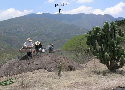
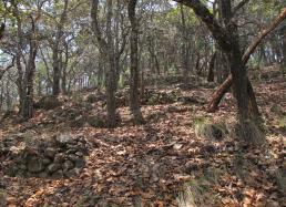
During the Guirún survey, Linda and I, along with our crew, walked over the tall ridge that forms the edge of the valley to the east. Although this ridge is well above the floor of the valley, we were surprised to discover a number of prehispanic sites. While all of these ridge-top sites were unexpected, the one that astounded us the most was the residential terrace site that we found just below several of the points or peaks that comprise the mountain known as Nueve Puntas (see above photo.)
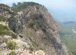
Nueve Puntas is both the highest and most distinctive part of its watershed ridge. From the valley-side, it’s a tall, majestic series of nine peaks that, on a clear day, can be seen even from hills at the center of the valley more than 40 kilometers away. From the south and west, outside the valley, Nueve Puntas is a steep rock cliff with a 500-meter drop-off (see Photo #1.)
It took me 19 years after I first set foot in the Valley of Oaxaca to have the chance to climb Nueve Puntas. Its distinctive features were etched in my memory from my first trip, but frankly I never suspected that anyone could have lived up there where a thick patch of pine forest now grows.
Initially, in 1995, I wondered whether our survey crew should even climb this peak, as the prospect for finding much on this steep mountain seemed slim. But, a few weeks into the 1995 fieldwork season, Linda and I decided we needed to climb it as we began to hear local accounts that there were “corrals” just below a few of the points.
At first, we had doubts about whether there could be a prehispanic site on Nueve Puntas, but the talk of corrals raised our interest, because, as unlikely as a prehispanic site seemed in this location, anyone ever tending a herd of large herbivores on the top of this steep mountain in the past was unquestionably far less probable.
In 1995, we left early in the morning to climb to Nueve Puntas. I remember surprisingly few details (one dog that accompanied us never returned), beyond that the slog up and down was long and hard and the prehispanic site that we “discovered” was characterized by incredible terrace (flat spots constructed on the steep slopes using stone retaining walls) preservation. The condition of the terraces was so astounding that you could see ramping entries, room foundations, and rectangular firepits.
I put quotes around “discovered” because actually many local people knew something old was there, but we were the first archaeologists to visit and map these ruins. There were also almost no fragments of pottery on the surface because of the heavy leaf/needle cover.
Linda and I ended up making two trips to Nueve Puntas in 1995 to map the site fully. Naturally, we included descriptions and maps of the site in our reports and mentioned it in passing fashion in several book/article chapters. We’re working on a final monograph for this survey, but we have another book that we need to put final touches on before we can focus more fully on the Guirún study.
As the years passed, we often wondered if we would ever get back to Nueve Puntas. No other archaeologist visited the site in the interim, and when we spoke of the site and its remarkable preservation, we sometimes wondered if people really believed us. During our ten seasons at El Palmillo, which sits on a ridge that flows down from one of Nueve Puntas’ peaks, we always saw the mountain, but never quite had the time or energy to return.
Well, finally this year, circumstances aligned and we were able to make a return hike to Nueve Puntas. Most of this mountain is in the lands of Santiago Matatlán, where we’re working with the people of this town on their community museum (which includes pieces from El Palmillo and has now expanded to two floors).
As with all Valley of Oaxaca towns, Matatlán has new municipal officials this year, and the incoming leaders wanted to meet us and visit the ruins with us. With this invitation, our entire crew (who were present at the time), along with several anthropologists and archaeologists from Mexico’s National Institute of Anthropology and History, and members of Matatán’s Municipal Council and Museum Committee, set out (25 strong) a bit after 6 a.m. from the town square of Matatlán to hike the hill.
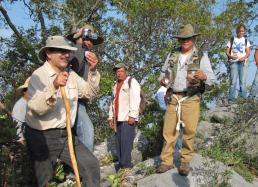
Matatlán’s new Presidente Municipal (mayor) did a brilliant job planning the trip and making sure that we not only hit the tops of all nine points, but that all 25 of us made it back safe and sound. Maybe that never was in doubt. On the first point up from Matatlán, we all partook in a local ritual sipping mescal and dropping some of this alcoholic liquid on to the rocks to thank the mountain for its presence and our protection (see Photo #2 below.)
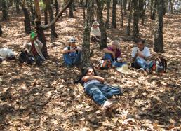
Later as we reached the middle of the nine peaks, we again found the site with its terraces and standing stone walls, fortuitously in pretty much the same condition we first found things 16 years ago (see Photo #4 below.) Around 11 hours after we set off, we reached a dirt road where the police vehicles from the town were all waiting to drive us back to the town square. I’m not sure when I might be ready for this hike again, but it clearly was an interesting way to transition from fieldwork to the lab, and it certainly was a day that I'll long remember.
More soon,
Gary

